DigiCad 3D 10 – Innovation in photogrammetry and cartography

DigiCad 3D is an architectural and aerial photogrammetry, cartography and mapping program born in 1987 and continuously renewed to follow the developments of the technique. We started from graphics tablets and large digitizers to get to drones and the future is not over yet.

To better meet new needs and new technological challenges, the program has been completely rewritten, both as a user interface and as an analytical code, using a cross-platform development system with advanced features and including new software technologies.

From Google Maps to Domus.Cad with Map2Cad

Map2Cad is a module of Domus.Cad Pro and Std, which enables you to import both satellite and road maps from Google Maps.

Maps are imported with actual measurements and represented in the video scale selected in Domus.Cad.

The main features of Map2Cad are:

  • Internal browser for viewing maps, with the Google Maps functions integrated
  • Import of maps
  • Managing a list of maps
  • Inserting the maps from the list into Domus.Cad
  • Maps are imported with actual measurements

The use of Map2Cad is very simple and allows for the integration of each of the Google maps features in Domus, including search functions, display choices, street view and more.

When you choose Map2Cad from the Domus.Cad Modules menu, the following dialog box appears:image01

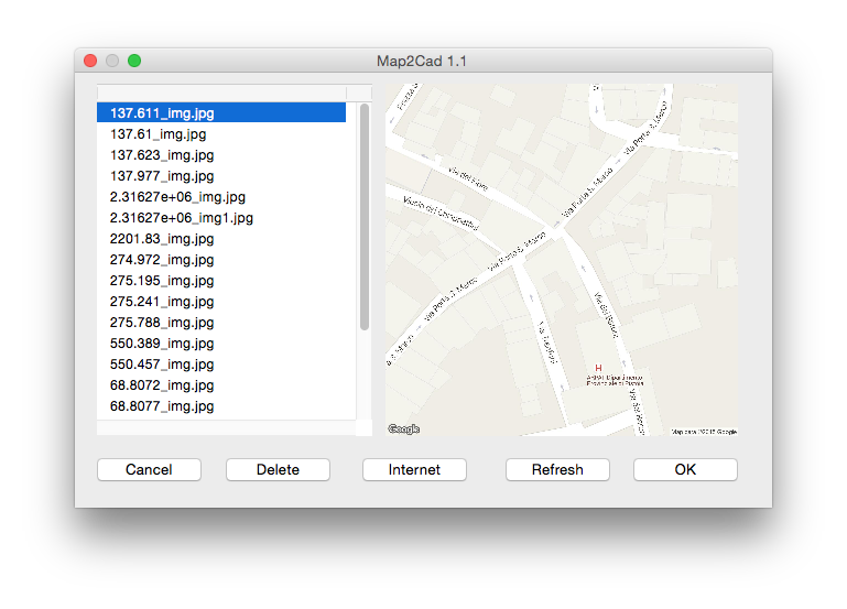
On the left, a list of previously imported maps appears.

Architectural photogrammetry – Mosaicing methods

Foto mosaico con DigiCad 3D
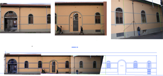
It is often impossible to take the entire facade of a building in just one photograph. You have to take several photos then mount them together in a mosaic to form the picture. 

Many programs claim to do mosaics of several photos, but what they actually mean can vary a lot. Some do no more than straighten up several photos in one document, leaving the user the task of mounting them together as best he can, with programs such as PhotoShop.

Excluding such kinds of program, many other alternatives remain:

DigiCad 3D 9 – The latest in photogrammetry

Interstudio has released DigiCad 3D 9 for Mac Os X. The Windows version will be out soon. The new version contains lots of new features, including: New algorithms for transforming images, for image rectification and irregular surfaces, too. Not only have we made the function much faster, it is also more accurate outside of attach…

DigiCad 3D 8.5 : What’s new?

DigiCad 3D is already well-known as a state-of-the-art program for the photogrammetry and cartography sectors.  Now it is offers some brilliant new functions for working with photographic images. Digital cameras are now widely used in architectural photogrammetry.  Unfortunately their big advantages (speed and ease of use) are often outweighed by the disadvantage of their not-very-wide-angle…