DigiCad 3D 10 – Innovation in photogrammetry and cartography

DigiCad 3D is an architectural and aerial photogrammetry, cartography and mapping program born in 1987 and continuously renewed to follow the developments of the technique. We started from graphics tablets and large digitizers to get to drones and the future is not over yet.

To better meet new needs and new technological challenges, the program has been completely rewritten, both as a user interface and as an analytical code, using a cross-platform development system with advanced features and including new software technologies.

CAD File Converter 4 – New version

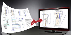
CAD File Converter‘s main purpose is to find its way among the various formats and versions of documents generated by Autodesk’s AutoCad and by numerous other programs using DXF, DWG, DWF, DXB and PDF formats.

CAD File Converter is a simple, easy-to-use tool that increases compatibility among the various CAD programmes, including between different versions of the same programme, as well as visualising and printing various drawing formats.

From Google Maps to Domus.Cad with Map2Cad

Map2Cad is a module of Domus.Cad Pro and Std, which enables you to import both satellite and road maps from Google Maps.

Maps are imported with actual measurements and represented in the video scale selected in Domus.Cad.

The main features of Map2Cad are:

  • Internal browser for viewing maps, with the Google Maps functions integrated
  • Import of maps
  • Managing a list of maps
  • Inserting the maps from the list into Domus.Cad
  • Maps are imported with actual measurements

The use of Map2Cad is very simple and allows for the integration of each of the Google maps features in Domus, including search functions, display choices, street view and more.

When you choose Map2Cad from the Domus.Cad Modules menu, the following dialog box appears:image01

On the left, a list of previously imported maps appears.

Domus.Cad 2.1 – New features

Version 2.1 of Domus.Cad Pro and Std, a complete BIM, parametric architectural 3D CAD, was released.

Major novelties include:
  • New “smart” inspector
  • OpenBim IFC 2×3 support
  • DXF, DWG, DWF and SVG import/export improvements
  • New RoofTiles module for creating 3D roof tiles
  • New Super2Dto3D module for easy and fast converting a 2D drawing to 3D model
  • New Map2Cad module for getting maps from Google Maps
  • SuperPipe and SupeRot improvements
  • Optimization for new operating system
  • New documentation with several movies
  • ..and many more

See details below.

Geo-Tec B 8 – Tiebacks and new interface

The new version 8 of Geo-Tec B is out with important new functions.

Geo-Tec B allows the verification of stratified slopes in the presence of water beds and loads. Some characteristics are graphic insertion of slope geometry, circular and generic sliding surfaces, stabilization with reinforced zones, pilings and tiebacks, submersed slopes and many others.

See below a detailed descriptions of some of the novelties of the new version 8.

Architectural photogrammetry – Mosaicing methods

Foto mosaico con DigiCad 3D
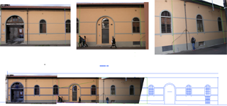
It is often impossible to take the entire facade of a building in just one photograph. You have to take several photos then mount them together in a mosaic to form the picture. 

Many programs claim to do mosaics of several photos, but what they actually mean can vary a lot. Some do no more than straighten up several photos in one document, leaving the user the task of mounting them together as best he can, with programs such as PhotoShop.

Excluding such kinds of program, many other alternatives remain:

All for one or one for all? What’s better, integrated or monolithic programs?

Any busy design studio nowadays needs many different kinds of software – a plain old design program just isn’t enough anymore!

The solution of many manufacturers has been to keep adding on different functions to the original software – design-through-production-through-application in a single, often unwieldy program. Autocad, Microstation and ArchiCad are examples.

The alternative is to develop state-of-the-art specialist programs, compatible and inter-communicating. This is the road chosen by Interstudio, for the following good reasons: