Several iPhone models, including the latest Apple iPhone 16 Pro and 16 Pro Max, have a lidar sensor inside, in practice a small laser scanner that allows you to detect architectural environments and objects and use the survey within BIM programs.
Domus.Cad Std and Pro allows you to use these clouds to quickly develop BIM and CAD projects.
iPhone Pro and Domus.Cad together constitute a BIM survey and design system, at least for small buildings, simple, fast and cheap compared to the expensive laser scanners.
The Lidar scanner
Apple has integrated a LIDAR scanner into the latest generations of Phone Pro and iPad Pro, offering advanced depth detection features. LiDAR stands for Light Detection and Ranging, a system which allows the distance of an object or surface to be determined using a laser pulse.
The range of the iPhone Lidar is about 5 m, with a precision of about 2 cm, enough to detect an entire building room by room. Only very high rooms remain outside, above 7 m. The width is not a problem, because the operator can move while detecting rooms.
The lidar can also be used to detect objects such as furniture, statues, cars etc.
Not suitable for outdoor use, where distances can be even much greater than 5 meters.
The iPhone models that contain the LIDAR scanner are: IPhone 12 Pro, iPhone 12 15 Pro Max, iPhone 13 Pro Max, iPhone 13 Pro Max, iPhone 14 Pro Max, iPhone 14 Pro Max, iPhone 15 Pro Max, iPhone 16 Pro and iPhone 16 Pro Max.
Costs range from around 400 € for a refurbished 12 Pro to 1489 € for an iPhone 16 Pro Max.
Currently Apple is the only manufacturer to insert in their smartphones Lidar scanners.
Some Android models may use photo-based survey systems, which can produce results similar to those described in this article.
Apps
There are many apps using the Lidar scanner, here are some names: CamToPlan, 3D lidar scanner, PolyCam, Scaninverse, 3D Scanner App, 3D Scanner, Luma 3D and others.
In this article we will talk about two free apps: Scaninverse and 3D Scanner app.

Scaninverse
Scaniverse by Niantic is a completely free app that allows you to use the Lidar scanner to detect both architectural environments and objects and export them in many formats, including Obj and LAS. The scan is done by moving slowly in the room, framing all the parts to be detected, as seen in the video.
After scanning you can choose how to process it, as shown in the figure.
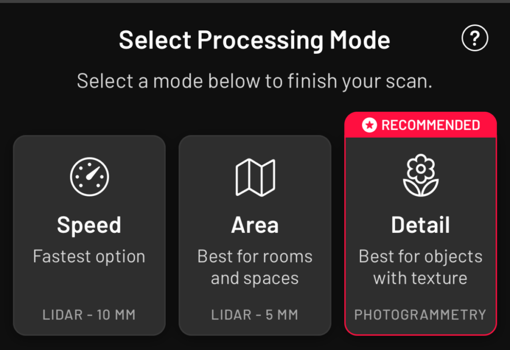
Where you can also choose the density of the points.
The app is shown in the movie below..
The OBJ format can be imported as a 3D model in Domus.Cad and the LAS format is imported as a point cloud.

3D Scanner App
3D Scanner App, by Lean Consulting Corp., is very similar in use to the Scan inverse described above, with a few more options. It’s this app that we used in the examples of processing with Domus.Cad.

Lidar, Lidar advance and Point Cloud are different ways of detecting point clouds.
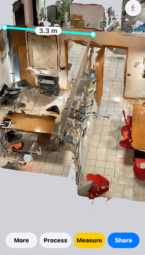
There are many export formats, including OBJ, Video and the Point Cloud LAS, PCD, PTS and other formats,
TrueDepth is a technology used by the front-facing camera to recognize faces and does not use the Lidar sensor.
RoomPlan is a purely photographic imaging system that we will see in the following examples, it does not use the Lidar sensor and uses the advanced iPhone camera system.
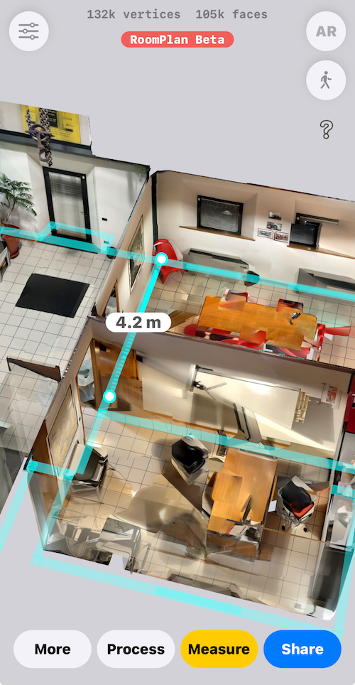
The export formats are many, including OBJ, but does not export point clouds, because they have not been detected,
The export formats are many, including OBJ, but does not export point clouds, because they have not been detected,
From iPhone to Domus.Cad
Let’s see two examples of the iPhone and Domus.Cad project development.
For both examples we used the 3D Scanner App, with two different methods: Point Cloud and RoomPlan.
With Point Cloud
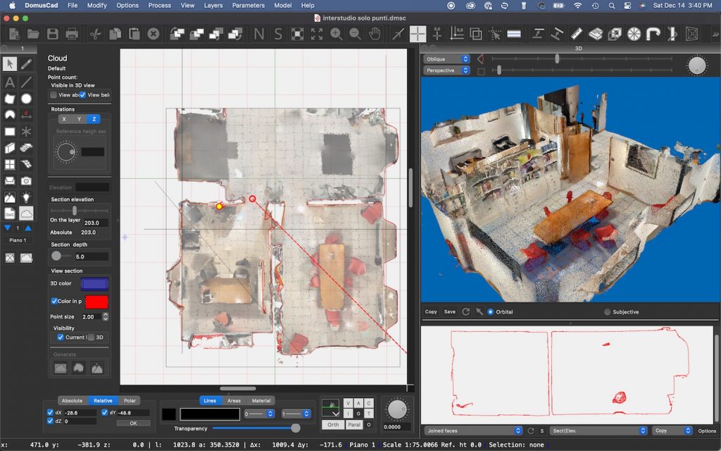
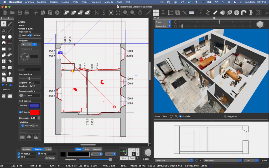
We exported from 3D Scanner App to LAS format, which is a format for point clouds. The LAS file was then imported with the command Import Cloud of points from the menu Layers.
In the image, the imported survey is shown in plan, in the 3D raster view and in section
Using the various point cloud management functions, BIM elements are inserted in the correct position. In practice the building is modeled with the possibility of having technical plans, sections, elevations, computations, three-dimensional views, rendering etc., as well as having the current basis for subsequent modifications.
With the RoomPlan method
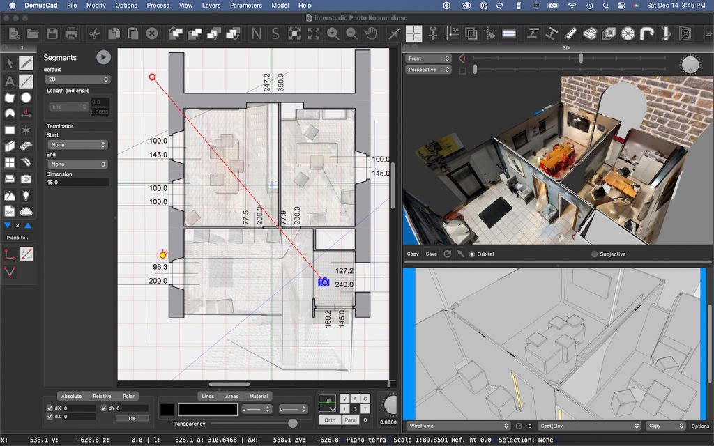
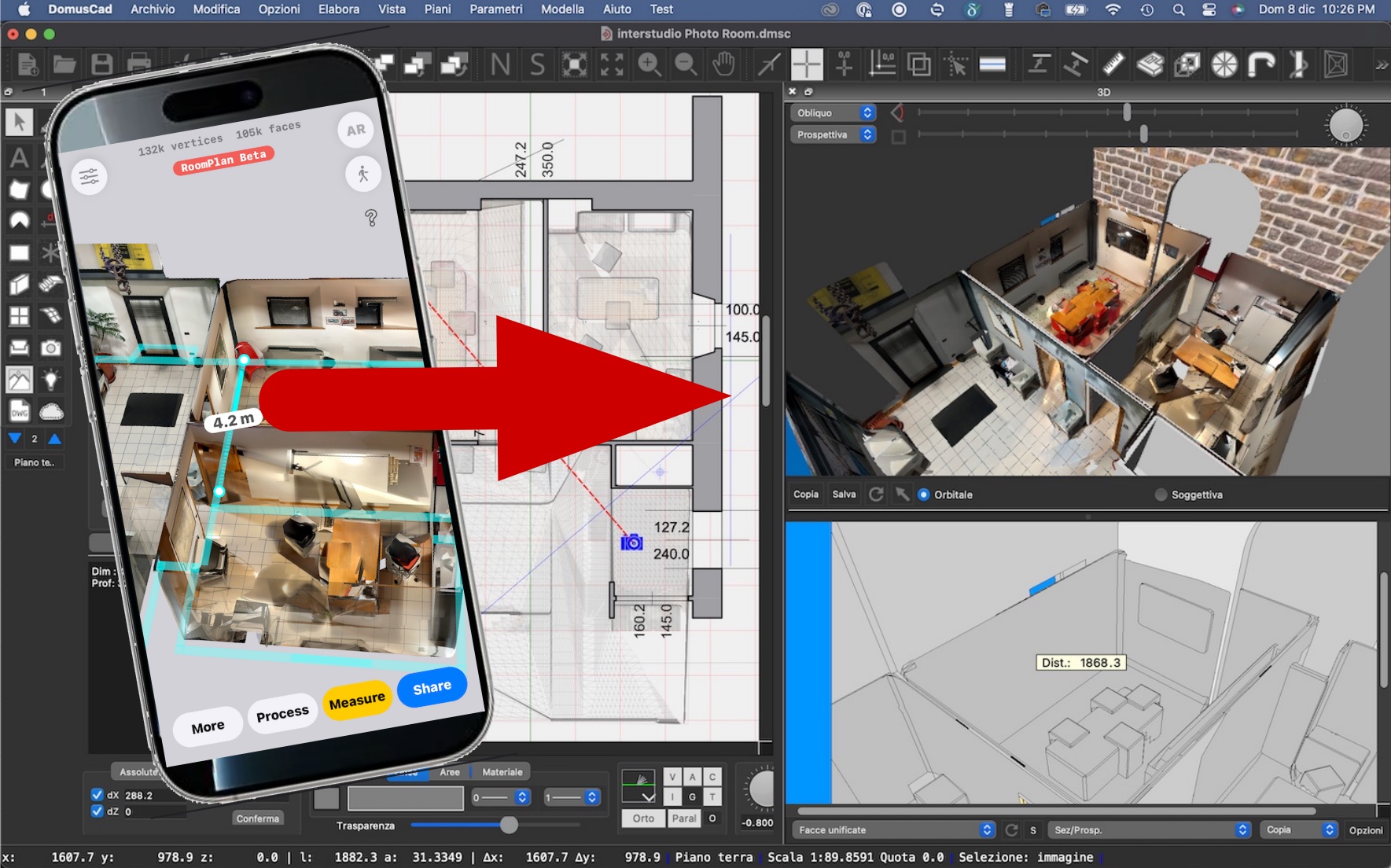
This method is used to recognize the corners of rooms and then walls, ceilings, columns. In addition, the others elements are recognized as parallelepipeds enclosing the element. Tables, chairs and furniture are taken up with the parallelepiped enclosing them.
Above these surfaces are applied as textures the photos taken by the 3 iPhone lenses.
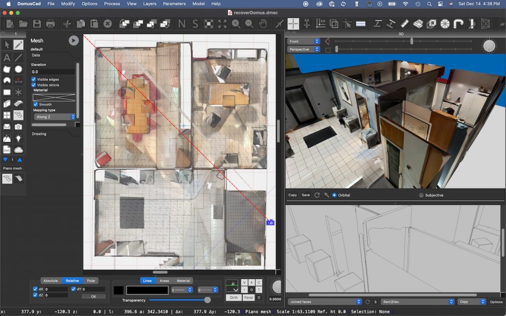
The mesh is exported by the app in OBJ format and imported from Domus.Cad with the command Import->3D model.
The imported mesh is used as a guide to insert BIM elements with correct positions and dimensions. Although the mesh is already three-dimensional, as can be seen from the previous image, the parametric BIM elements allow for more complete elaborations of the project, with standard graphical representations for pals, sections and elevations and subsequent variations to design changes to the existing.
After the insertion of walls, floors, doors and windows
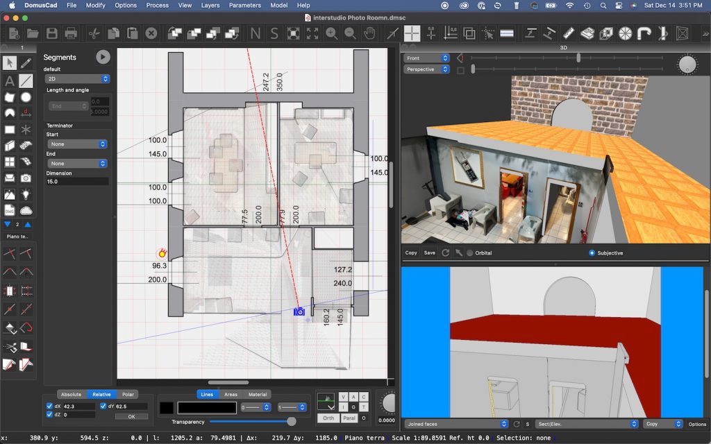
After the insertion of walls, floors, doors and windows
These examples are a few rooms survey, but the Apple iPhone can be used for much larger survey, room by room an entire building can be detected.
For larger systems it is better to divide the work into multiple point clouds or meshes. Domus.Cad has the tools to reassemble them later with precision, realigning the various parts with common points or some support measures.
Domus.Cad and Cloud Point
Domus.Cad allows advanced management of point clouds.
Download and try 239 € Rent To Own Special offerHere are some articles that allow for a deeper understanding of these topics.
-
Point Cloud fast with Domus.Cad
-
New version 24.3.2 of Domus.Cad
-
From Point Cloud to BIM
-
Irene Chirico in the Cloud
-
Domus.Cad 24 – Clouds in BIM
Some useful movies


