New DigiCad 3D with PDF conversion and image drilling

The version 23.0.1 of DigiCad 3D has been released which, among the various improvements, includes two very important functions, the conversion of PDFs into vector drawings, documents, graphics, etc., and the cropping of images, both for drilling and for cutting.   Remember that DigiCad 3D is an aerial, terrestrial and cartographic photogrammetry program. PDF Conversion…

DigiCad 3D 10 – Innovation in photogrammetry and cartography

DigiCad 3D is an architectural and aerial photogrammetry, cartography and mapping program born in 1987 and continuously renewed to follow the developments of the technique. We started from graphics tablets and large digitizers to get to drones and the future is not over yet.

To better meet new needs and new technological challenges, the program has been completely rewritten, both as a user interface and as an analytical code, using a cross-platform development system with advanced features and including new software technologies.

Architectural photogrammetry – Mosaicing methods

Foto mosaico con DigiCad 3D
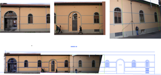
It is often impossible to take the entire facade of a building in just one photograph. You have to take several photos then mount them together in a mosaic to form the picture. 

Many programs claim to do mosaics of several photos, but what they actually mean can vary a lot. Some do no more than straighten up several photos in one document, leaving the user the task of mounting them together as best he can, with programs such as PhotoShop.

Excluding such kinds of program, many other alternatives remain: